ข้อมูลการปฏิบัติที่ดีที่สุด (Best Practice) ของนครกวางโจว สาธารณรัฐประชาชนจีน
โครงการเส้นทางสีเขียวตงห่าวชง (Donghaochong Greenway Project)
การสร้างพื้นที่สีเขียวในเมืองที่มีประชากรหนาแน่น
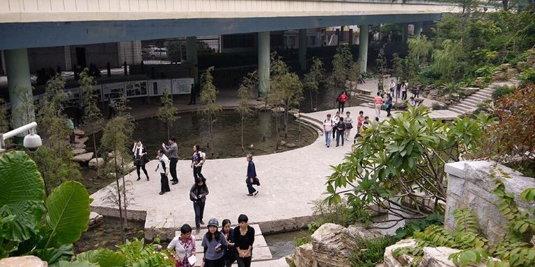
ภาพโดย Karl Fjellstrom/Far East BRT
เส้นทางสีเขียวตงห่าวชง (Donghaochong Greenway) นครกวางโจว เป็นหนึ่งในตัวอย่างตัวอย่างที่ดีที่สุดของสาธารณรัฐประชาชนจีนในการปรับปรุงพื้นที่สาธารณะและช่องทางการสัญจรในเมืองที่มีประชากรหนาแน่น
ข้อมูลทั่วไป
เส้นทางสีเขียวตงห่าวชงในนครกวางโจวเป็นต้นแบบในการสร้างพื้นที่สีเขียวเพื่อการพักผ่อนหย่อนใจและการเพิ่มช่องทางการสัญจรในเมืองที่มีประชากรหนาแน่น เป็นพื้นที่ใต้ทางยกระดับประกอบด้วยเส้นทางที่มีการปรับภูมิทัศน์สวยงาม ทางเดิน ทางจักรยาน และลำคลองที่ได้รับการฟื้นฟู
ข้อมูลทั่วไปของโครงการ
- ระยะเวลาดำเนินการ
- เริ่มการก่อสร้าง พ.ศ. 2552
- เปิดให้บริการเดือนกรกฎาคม 2553
- งบประมาณ
- การลงทุนสร้างพื้นที่สีเขียว จำนวน 30,000 ล้านหยวน (4,800 ล้านดอลลาร์สหรัฐ ณ พ.ศ. 2555)
- การฟื้นฟูสภาพคลอง ความยาว 1.89 กิโลเมตร จำนวน 1,038 ล้านหยวน (1,680 ล้านดอลลาร์สหรัฐ ณ พ.ศ. 2555)
- หน่วยงานที่เกี่ยวข้อง
ด้านงบประมาณ:
- นครกวางโจว (Guangzhou Municipal Government)
การวางแผนและออกแบบ:
- คณะกรรมการด้านการคมนาคมนครกวางโจว (Guangzhou Communication Commission)
การดำเนินการ:
- คณะกรรมการด้านการคมนาคมนครกวางโจว (Guangzhou Communication Commission)
บริบทโครงการ
ในเดือนธันวาคม 2551 นครกวางโจวเริ่มการฟื้นฟูและขุดลอกคูคลองในเขตเยว่เฉี่ยว (Yuexiu District) ซึ่งเป็นย่านใจกลางเมืองที่เก่าแก่ที่สุด การดำเนินการครอบคลุมแม่น้ำลำคลองที่เป็นทางระบายน้ำซึ่งเคยเป็นแหล่งน้ำสำหรับการอุปโภคบริโภค โดยบางส่วนถูกถนนสร้างทับ
ในการเตรียมพร้อมการเป็นเจ้าภาพเอเชียนเกมส์ในเดือนพฤศจิกายน 2553 ของนครกวางโจว รัฐบาลได้เห็นชอบให้เร่งรัดดำเนินโครงการทำความสะอาดคลองตงห่าวชง ซึ่งคลองสายนี้ได้กลายเป็นส่วนหนึ่งของโครงการพัฒนาเมืองเพื่อสร้างเส้นทางสีเขียวที่ออกแบบเพื่อส่งเสริมการเดินทางโดยไม่ใช้ยานยนต์
เช่น การเดิน การปั่นจักรยาน เป็นต้น เพื่อปรับปรุงช่องทางการสัญจร รวมถึงลดการใช้เชื้อเพลิงและลดมลพิษ
คลองตงห่าวชงมีมาตั้งแต่สมัยราชวงศ์ซ่ง ใช้เป็นแนวป้องกันเมือง ช่องทางการคมนาคม
ทางระบายน้ำเสีย และทางน้ำล้นเพื่อระบายน้ำฝน คลองสายนี้ไหลลงแม่น้ำไข่มุก (Pearl River) เป็นคลองขนาดใหญ่ที่ทอดยาวแนวเหนือ-ใต้เพียงสายเดียวที่ไม่ได้ถูกถนนสร้างทับ และมีทางยกระดับสร้างเหนือคลองดังกล่าว
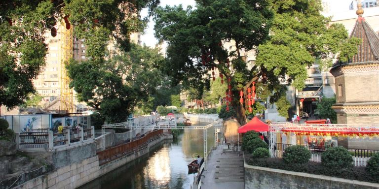
การทำความสะอาดคลองตงห่าวชงเป็นส่วนหนึ่งของโครงการพัฒนาเมืองเพื่อสร้างเส้นทางสีเขียว
ภาพโดย Lloyd Wright/ADB
ความท้าทายในการดำเนินโครงการ
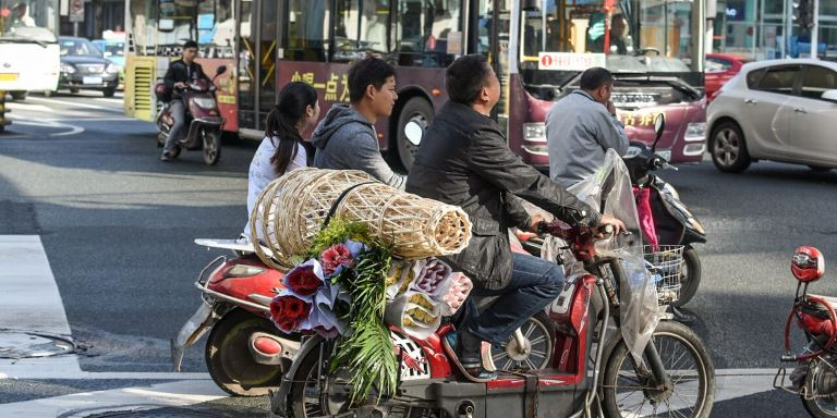
เมืองที่เติบโตอย่างรวดเร็วต้องเผชิญกับปัญหาต่าง ๆ รวมถึงการจราจรติดขัดและมลพิษที่เพิ่มสูงขึ้น
ภาพโดย Deng Jia/ADB
สภาพแวดล้อมภายในเมืองที่เสื่อมสภาพ
การพัฒนาเมืองอย่างรวดเร็วและการเพิ่มขึ้นของประชากรก่อให้เกิดปัญหาแก่นครกวางโจวและประชาชนภายในเมือง นครกวางโจวไม่สามารถแก้ไขปัญหาการจราจรติดขัดและมลพิษที่เพิ่มสูงขึ้นด้วยการขยายโครงสร้างสาธารณูปโภคเพียงอย่างเดียว จะต้องพัฒนาคุณภาพชีวิตของประชาชนภายในเมืองด้วย
น้ำเน่าเสียและน้ำท่วม
น้ำในคลองตงห่าวชงมีภาวะเน่าเสียมาก ถึงแม้จะเป็นทางระบายน้ำเสียแต่ยังคงมีประชากรอาศัยอยู่บริเวณริมสองฝั่งคลองรวมถึงสร้างอาคารบ้านเรือนต่าง ๆ บางครั้งน้ำเสียในคลองเกิดการเอ่อล้นและไหลลงสู่ย่านที่อยู่อาศัยและย่านธุรกิจใกล้เคียง
แนวทางแก้ไขปัญหา
สร้างเมืองที่ปลอดภัยและน่าดึงดูดสำหรับการเดินและปั่นจักรยาน
ใน พ.ศ. 2552 มีการปรับภูมิทัศน์ในพื้นที่ตามแนวคลองตงห่าวชงกว่า 7 เฮกตาร์ (70,000 ตารางเมตร) ให้เป็นเส้นทางสีเขียว โดยประชากรเกือบ 1,000 ครอบครัว และอาคารพาณิชย์ในพื้นที่กว่า 48,000 ตารางเมตร ต้องย้ายที่อยู่ใหม่
เส้นทางสีเขียวส่วนใหญ่ทอดผ่านตามคลอง ยกเว้นเส้นทางฝั่งเหนือซึ่งตัดผ่านพื้นที่ที่มีความหนาแน่นของประชากรสูง
เส้นทางสีเขียวตงห่าวชงเป็นหนึ่งในเส้นทางสีเขียวที่นครกวางโจวพัฒนาขึ้นเพื่อสร้างทางเดินและทางจักรยานแห่งใหม่ภายในเมือง เป็นเส้นทางที่ต่อเนื่องและสวยงาม เชื่อมต่อกับระบบขนส่งสาธารณะ สามารถเดินหรือปั่นจักรยานและต่อรถประจำทางหรือรถไฟใต้ดินเพื่อเดินทางในระยะไกลแทนการใช้รถได้สะดวกยิ่งขึ้น

นครกวางโจวสร้างทางเดินและทางจักรยานที่ปลอดภัยและสวยงามเพื่อสนับสนุนการเดินทางภายในเมืองโดยไม่ใช้ยานยนต์ ภาพโดย Karl Fjellstrom/Far East BRT
ฟื้นฟูคลองตงห่าวชง
พื้นที่คลองทั้งหมดได้รับการขุดลอกและทำความสะอาด การดำเนินโครงการในระยะแรกเสร็จสิ้นในเดือนมิถุนายน 2553 นครกวางโจวสร้างสะพานข้ามคลอง 10 แห่ง ทางเดิน 5.4 กิโลเมตร
ทางจักรยาน 1.3 กิโลเมตร และถนน 3.2 กิโลเมตร นอกจากนี้ นครกวางโจวได้เปิดพิพิธภัณฑ์คลองตงห่าวชงเพื่อเป็นแหล่งข้อมูลที่เกี่ยวข้องและประวัติความเป็นมาของคลองตงห่าวชง
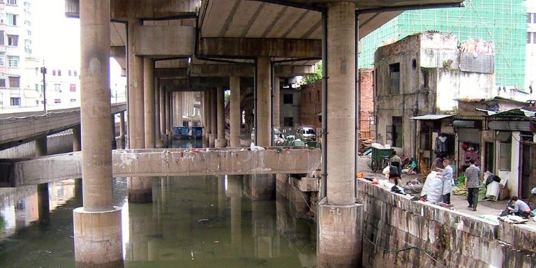
คลองตงห่าวชงก่อนการสร้างเส้นทางสีเขียว ภาพโดย Karl Fjellstrom/Far East BRT
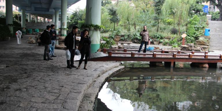
คลองตงห่าวชงหลังการฟื้นฟูภูมิทัศน์ ภาพโดย Lloyd Wright/ADB
สถิติและข้อเท็จจริง
- โครงการระยะแรกสร้างสะพาน 10 แห่ง ทางเดิน 5.4 กิโลเมตร ทางจักรยาน 1.3 กิโลเมตร และถนน 3.2 กิโลเมตร
- มีการพัฒนาอสังหาริมทรัพย์เชิงพาณิชย์กว่า 329,000 ตารางเมตร ในบริเวณพื้นที่โดยรอบ
- คลองตงห่าวชงมีความยาว 4,225 เมตร กว้าง 7 – 11 เมตร
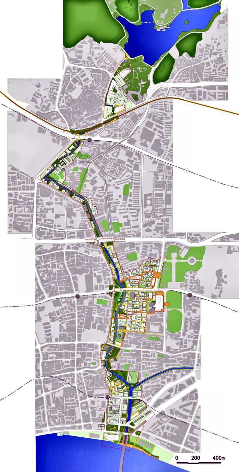
แผนที่โครงการ ภาพโดย https://www.fareast.mobi/en/bestpractices/donghaochong
ผลการดำเนินโครงการ

เส้นทางสีเขียวตงห่าวชง ภาพโดย Karl Fjellstrom/Far East BRT
สถิติสำคัญ
- ตั้งแต่การเปิดเส้นทางสีเขียวในปี 2553 จนถึงปี 2556 อัตราค่าเช่าสูงขึ้นร้อยละ 30
- มีการสร้างงานกว่า 300,000 ตำแหน่ง
สิ่งที่ได้จากการดำเนินโครงการ
บูรณาการการใช้ที่ดินร่วมกับการวางแผนด้านการขนส่ง
ถึงแม้ว่าโครงการเส้นทางสีเขียวตงห่าวชงจะไม่ได้มีความร่วมมือโดยตรงกับรถโดยสารประจำทางด่วนพิเศษนครกวางโจว (BRT) แต่ทั้งสองฝ่ายต่างได้ประโยชน์ร่วมกันด้วยการสร้างพื้นที่เฉพาะสำหรับ
การเดินและการปั่นจักรยาน ซึ่งมีส่วนช่วยปรับปรุงการสัญจรภายในเมืองที่มีความหนาแน่นประชากรสูง
ลดการใช้รถยนต์ และลดการปล่อยมลพิษ รวมถึงได้เชื่อมต่อกับเครือข่ายบริษัทเช่าจักรยานของเอกชน
ซึ่งความคิดริเริ่มเหล่านี้ล้วนส่งเสริมความเป็นเมืองน่าอยู่และภาพลักษณ์ที่ดีของนครกวางโจว
พื้นที่สาธารณะมีบทบาทสำคัญในความยั่งยืนของเมือง
โครงการเส้นทางสีเขียวของนครกวางโจวได้สร้างพื้นที่สาธารณะสำหรับการพักผ่อนหย่อนใจและการสัญจรโดยไม่ใช้ยานยนต์ รวมถึงได้อนุรักษณ์สิ่งแวดล้อม สร้างความสวยงามให้แก่ชุมชนโดยรอบ
เพิ่มมูลค่าที่ดิน ขยายการพัฒนาพื้นที่เชิงพาณิชย์ และกลายเป็นแหล่งท่องเที่ยว ในขณะเดียวกัน โครงการดังกล่าวได้ช่วยปรับปรุงการใช้ที่ดินและการพัฒนาเมือง ซึ่งมีส่วนช่วยให้นครกวางโจวเป็นตัวอย่างของการพัฒนาอย่างยั่งยืน
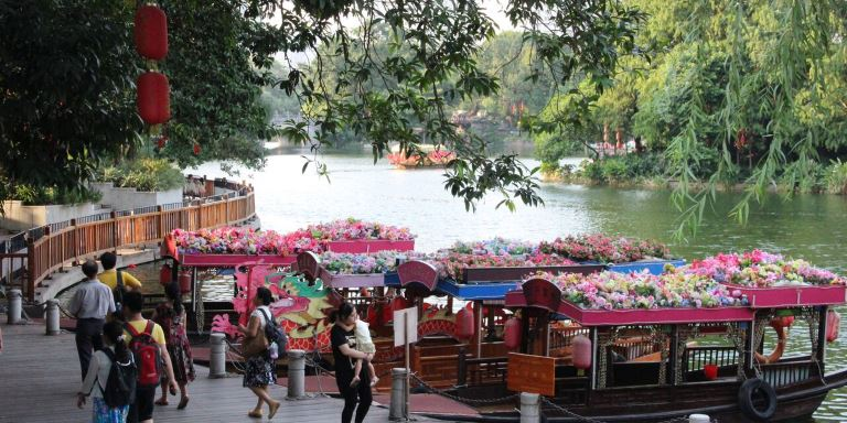
โครงการเส้นทางสีเขียวของนครกวางโจวเปลี่ยนให้พื้นที่เป็นแหล่งท่องเที่ยว ภาพโดย Lloyd Wright/ADB
ชุมชนมีส่วนร่วมในโครงการ
มีการย้ายที่ตั้งบ้านเรือนและอาคารพาณิชย์ริมคลองตงห่าวชงจำนวนมาก เจ้าหน้าที่ท้องถิ่นจึงมีการปรึกษาและทำงานอย่างใกล้ชิดร่วมกับชุมชนท้องถิ่นเพื่อความราบรื่นในการดำเนินโครงการ
แหล่งข้อมูล
- เว็บไซต์ของนครกวางโจว (Guangzhou Municipal Government)
- Suzuki, R. Cervero, and K. Luchi. 2013. Transforming Cities with Transit: Transit and Land-Use Integration for Sustainable Urban Development. Washington D.C.: World Bank.
- 2012. Best Practices in Urban Development in the Pearl River Delta. Guangzhou.
- 2013. ADB-CAF South-South Cooperation Virtual Study Tour Final Report. Unpublished.
Donghaochong Greenway Project
Creating Green Spaces in a Congested City (Guangzhou)

Photo credit: Karl Fjellstrom/Far East BRT, Creative Commons Attribution License.
Guangzhou's Donghaochong Greenway is one of the best examples in the People's Republic of China for improving public space and mobility in a highly populated city.
Overview
The Donghaochong Greenway in Guangzhou is a model for creating green spaces for recreation and increased mobility in a highly congested city. It features a landscaped corridor with winding walkways and bicycle paths, and a restored stream under an elevated highway.
Opened in 2010, Donghaochong Greenway is part of an ambitious project to develop high-quality green spaces throughout Guangzhou, the third largest city in the People's Republic of China (PRC). By 2013, the municipal government had developed over 3,000 kilometers (km) of greenways. The project has helped improve living conditions for residents and raised land values in the surrounding areas.
Project snapshot
- Dates
- 2009: Construction
- July 2010: Operation
- Cost
- CNY30 billion ($4.8 billion in 2012 equivalent) :Total investment in greenways
- 038 billion ($1.68 billion 2012 equivalent) :Total cost of 1.89 km canal reclamation
- Institutions and Stakeholders
Financing:
- Guangzhou Municipal Government
Planning and design:
- Guangzhou Communication Commission
Executing agency:
- Guangzhou Communication Commission
Context
In December 2008, Guangzhou began cleaning up and restoring waterways in Yuexiu District, its oldest downtown area. These include streams and rivers that used to supply water to the city and later became sewage canals. Some have been covered over by road infrastructure.
In preparation for Guangzhou's hosting of the Asian Games in November 2010, the government decided to put the cleanup of Donghaochong Canal on the fast track. The canal also became part of an urban improvement project to create greenways, which were designed to promote nonmotorized travel (e.g. walking, cycling) and improve mobility as well as reduce fuel use and pollution.
Donghaochong Canal has existed since the Song Dynasty. It was used in urban defense and as a transport corridor, sewer, and stormwater spillway. The stream flows into the Pearl River and it is the only major north-south channel in the city that has not been covered. An elevated expressway stands over it.

The cleanup of Donghaochong Canal was part of an urban improvement project to create greenways. Photo credit: Lloyd Wright/ADB.
Challenges

Worsening traffic congestion and pollution are among the challenges faced by rapidly growing cities. Photo credit: Deng Jia/ADB.
Deteriorating city environment
Rapid urban development and population growth were taking their toll on Guangzhou and its residents. The city could not solve traffic congestion problems and the worsening pollution by merely building more infrastructure. There was a need to improve the quality of life in the city.
Water pollution and flooding
Donghaochong Canal was heavily polluted. It was an open sewer, but this did not stop people from settling along its banks or from putting up buildings. Water in the canal sometimes overflowed, spilling sewage into nearby residential and commercial areas.
Solutions
Make the city safe and attractive for walking and biking
Starting in 2009, over 7 hectares of land along the Donghaochong Canal were cleared and turned into a greenway. Nearly a thousand families and about 48,000 square meters of commercial buildings had to be relocated.
Most of the greenway is located along the canal except for its northern section, which passes through a densely populated area.
The Donghaochong Greenway was just one of the greenways that Guangzhou developed to provide new walkways and bicycle paths in the city. These continuous landscaped corridors were also connected to the public transportation system. This made it easier to just walk or ride a bicycle and then transfer to a bus or the metro for longer trips instead of using a car.

Guangzhou built safe and attractive pedestrian and bicycle paths to promote nonmotorized transport in the city. Photo credit: Karl Fjellstrom/Far East BRT, Creative Commons Attribution License.
Restore the Donghaochong Canal
The entire canal was dredged and cleaned. The first phase of development was completed in June 2010. The city built 10 bridges across the canal, 5.4 km of walkways, 1.3 km of bike paths, and 3.2 km of roads. It also opened the Donghaochong Canal Museum, which provides information on the canal and its history.

Donghaochong canal before the greenway; Photo credit: Karl Fjellstrom/Far East BRT, Creative Commons Attribution License.

After the restoration of the canal; Photo credit: Lloyd Wright/ADB.
Numbers and facts
- First phase 10 bridges, 5.4 km of walkways, 1.3 km of bicycle paths, and 3.2 km of roads
- More than 329,000 m2 of commercial real estate are being developed in the surrounding area
- Donghaochong Canal Length: 4225 m / Width: 7-11 m

Image source: https://www.fareast.mobi/en/bestpractices/donghaochong
Results

Donghaochong Greenway; Photo credit: Karl Fjellstrom/Far East BRT, Creative Commons Attribution License.
Key statistics
- 30% increase in rent from the opening of the greenway in 2010 until 2013
- Over 300,000 jobs were created
Lessons
Integrate land use and transport planning
The Donghaochong Greenway was not directly coordinated with the Guangzhou Bus Rapid Transit (BRT) project. Yet, they complement each other. Both provide dedicated spaces for walking and cycling, which help improve mobility in the highly congested city, reduce the use of cars, and lessen pollution. They also connect to the public bike-rental network. Together, these initiatives have enhanced livability in Guangzhou and the city's image.
Public spaces play a key role in urban sustainability
Guangzhou's greenways project created public spaces for recreation and nonmotorized transport as well as environmental conservation. It has made neighborhoods in the area more attractive. Land values and commercial development have increased. The greenways have also become a tourist attraction. At the same time, the project has helped improve land use and urban development in the city. It has contributed in making Guangzhou a showcase for sustainable development.

Guangzhou's greenways project has made the area a tourist attraction.
Photo credit: Lloyd Wright/ADB.
Involve the community in the project
There were houses and commercial buildings along the Donghaochong Canal that needed to be relocated. Local authorities consulted and worked closely with the local community to ensure the smooth implementation of the project.
Resources
- Guangzhou Municipal Government website
- Suzuki, R. Cervero, and K. Luchi. 2013. Transforming Cities with Transit: Transit and Land-Use Integration for Sustainable Urban Development. Washington D.C.: World Bank.
- 2012. Best Practices in Urban Development in the Pearl River Delta. Guangzhou.
- 2013. ADB-CAF South-South Cooperation Virtual Study Tour Final Report. Unpublished.
https://development.asia/case-study/creating-green-spaces-congested-city
เอกสารแนบ : Best Practice - นครกวางโจว Donghaochong (ฐิติกร).pdf